3 private links
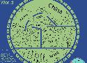
Reddit user xilefakamot created this in 2020 — a “topologist’s map of the world.” It depicts international borders and nothing else — the shapes, sizes, and distances between countries are forsaken in order to present the pattern of their borders as efficiently as possible. “No calculations per se – I sketched out a series of networks showing which countries bordered each other, then gradually smoothed them out to make the map – all done manually.” (Via MapPorn.)


by year, since 3000 BC. Universal History datasets. Relevant Universal History vector information.
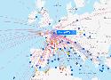
Direct flights from more than 900 airlines on an interactive flight map. Search, find and compare any flight path or airline route with our flight maps!
Interactive world light pollution map. The map uses NOAA/EOG VIIRS, World Atlas 2015, Aurora prediction, observatories, clouds and SQM/SQC overlay contributed by users.
systme d'information gographique de la CUS